Mapping Sectors
| site analysis |
Sector planning is concerned with energies external to our site, the elements and forces of Nature, that come from outside our system, and pass through it.
These energies include:
Since these wild energies come into our system from outside, we can strategically place elements in our design to manage or take advantage of these incoming energies.
By placing plants, trees or structures in the appropriate areas, we can:
Mapping Sectors
To map out how these wild energies interact with our site, we can use a sector diagram.
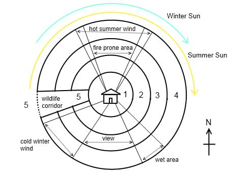
Each sector indicates one of the external energies discussed above, and is usually represented as a wedge shape, like a slice of a pie, radiating our from the centre of activity, Zone 0, the home, but it can be any other structure of central focus if necessary.
Together, zone planning and sector planning cover the management of energy inside the site and external energies flowing through the site respectively. Once we have completed our zone and sector analysis, we can then consider one more factor in efficient energy planning, that is the concept of Slope. The contour of the land has a considerable bearing on the design of the site, so this topic will be discussed on the following section.
The diagram below shows a sector diagram for the southern hemisphere, with the sun to the north.
These energies include:
- hot summer winds
- cold winter winds
- winter and summer sun angles
- salty or damaging winds
- water flow and flood prone areas
- unwanted views
- fire danger areas
Since these wild energies come into our system from outside, we can strategically place elements in our design to manage or take advantage of these incoming energies.
By placing plants, trees or structures in the appropriate areas, we can:
- Block the incoming energy: Block strong winds or intense mid-summer light with placement of deciduous trees on the western side of a house.
- Channel the incoming energy for our intended use: Water flowing into our site, either from directly above as rain, from run-off coming from adjacent properties, or collecting in an area (such as a flood prone area) can be redirected into lakes, dams, ponds, irrigation channels, swales and other water management systems.
- Open the area to allow the incoming energy in: Sunlight is one of the elements of nature that we might want to increase in our design. If we have structures or trees blocking the light reaching our Zone 1 kitchen garden for example, rather than relocate the garden, we can clear the area to allow more light in. Where places are too shaded, we can thin out trees or branches to increase productivity from our available space.
Mapping Sectors
To map out how these wild energies interact with our site, we can use a sector diagram.
Each sector indicates one of the external energies discussed above, and is usually represented as a wedge shape, like a slice of a pie, radiating our from the centre of activity, Zone 0, the home, but it can be any other structure of central focus if necessary.
Together, zone planning and sector planning cover the management of energy inside the site and external energies flowing through the site respectively. Once we have completed our zone and sector analysis, we can then consider one more factor in efficient energy planning, that is the concept of Slope. The contour of the land has a considerable bearing on the design of the site, so this topic will be discussed on the following section.
The diagram below shows a sector diagram for the southern hemisphere, with the sun to the north.


